
A mineral resource estimate is sometimes presented as if it were a relatively simple workflow:

Instead, the more challenging part is deciding what data should be used, how the geology should be represented, which samples belong together, how spatial continuity should be interpreted, what assumptions should be made during estimation, and how the final model should be tested.
In other words:
Resource estimation is not primarily a software process. It is a geological, statistical, and geostatistical reasoning process implemented through software.
This is also reflected in modern resource-estimation literature. Rossi and Deutsch (2014) describe the workflow through statistical analysis, geological controls, estimation domains, data handling, spatial variability, recoverable resources, simulation, validation, reconciliation, and uncertainty. The AusIMM Guide to Good Practice similarly emphasizes contemporary, non-prescriptive workflows rather than a single estimation recipe (AusIMM, 2014).
1. The Resource Database — Garbage In, Garbage Out
-and-garbag-out-(the-result-of-unreliable-data-processing)-(snowden,-2009).webp)
Before building a geological model, we need to establish whether the data itself is valid and trustworthy. This is arguably the least glamorous part of resource estimation, but it is one of the most consequential.
A resource model may contain millions of estimated blocks, but all of those blocks ultimately depend on a relatively small number of geological observations.
The typical starting dataset includes:
Collar information
Downhole surveys
Assays
Lithology
Alteration
Mineralization
Density
Sampling intervals
QA/QC information
The first task is therefore data validation. You might want to ask these questions:
Are the drillhole coordinates correct?
Do assay intervals overlap?
Are there gaps?
Are sample depths consistent with geological logging?
Are there duplicate records?
Are the geological codes consistent?
Are there anomalous values that require investigation?
Another important consideration is the data cut-off date. A Mineral Resource estimate represents the geological knowledge available at a particular point in time. Therefore, the database used for the estimate should have a clearly defined cut-off date that is appropriate for the reporting purpose (AusIMM, 2014; JORC, 2012).
This stage is not simply about finding database errors. It is also about understanding how the data was generated.
Sampling protocols, sample preparation, analytical methods, recovery and representativity, detection limits, laboratory performance, standards, blanks, and duplicates all contribute to the confidence that can be placed in the resulting database. The quality and representativity of sampling are particularly important because a technically correct database does not necessarily mean that the samples adequately represent the mineralization.
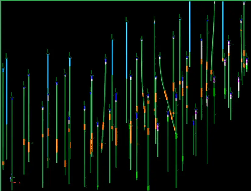
In Surpac, this stage connects conceptually to:

Surpac is designed to manage drillhole data and perform statistical and geostatistical analysis as part of the resource-modeling workflow. But the software cannot determine whether a sample collection protocol was appropriate or whether a laboratory issue compromises the data. That remains a geological and quality-control responsibility. The first question in resource estimation is not “Which algorithm should I use?” It is “Can I trust the data?”
2. Geological Interpretation — Turning Data into a Geological Model
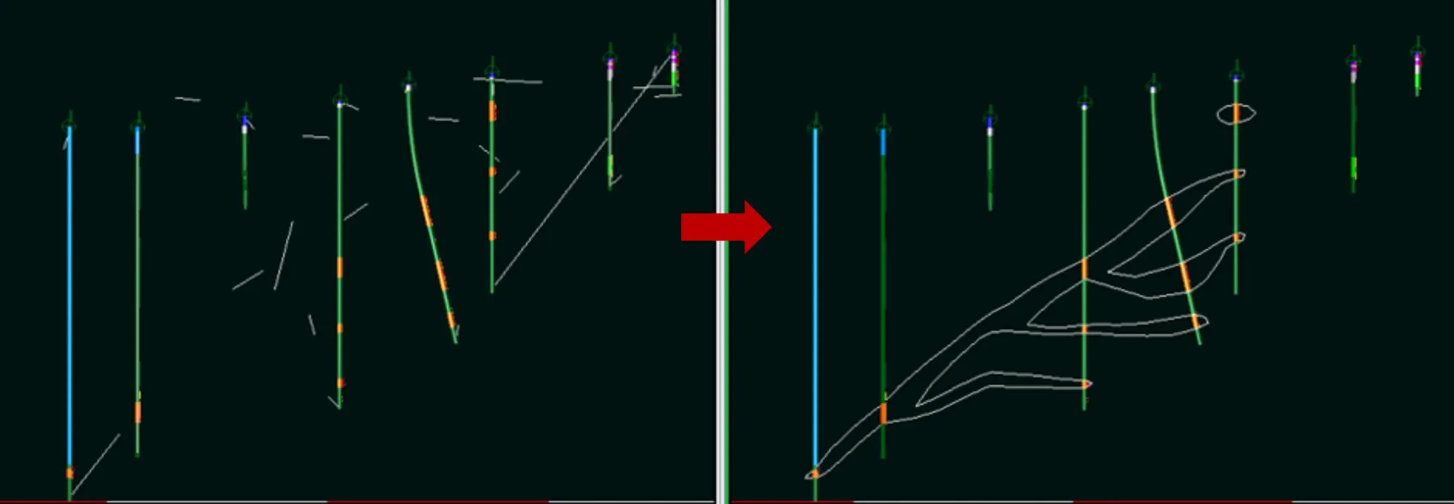
Once the database is considered reliable, the next challenge is to understand the geology. Drillholes provide discrete observations of a much larger and spatially continuous geological system. The geologist's task is to use these limited observations, together with geological knowledge, to interpret the three-dimensional distribution and controls of mineralization.
In Surpac, this might involve displaying drillholes in sections, interpreting geological contacts, creating strings, generating solids, and constructing surfaces or wireframes. The interpretation should consider the geological controls on mineralization.
For example:
Lithology
Alteration
Structure
Veining
Weathering
Stratigraphy
Mineralization style
Structural orientation
These controls determine how we should later define estimation domains.
This is important because a resource model is not simply an interpolation of grades. It is an interpolation performed within a geological framework. Rossi and Deutsch (2014) explicitly discuss geological controls and block modeling before estimation domains and spatial variability in their treatment of mineral resource estimation.
A typical Surpac workflow could be:

Surpac provides 3D geological modeling and wireframing tools as part of its resource-modeling capabilities. Before estimating grades, we need to understand what controls the grades and to what extent each factor influences it.
3. Estimation Domains — One of the Most Important Decisions
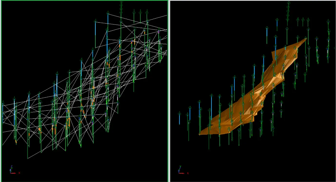
A resource model is rarely estimated as a single statistical population across the whole deposit. Instead, it is divided into estimation domains: volumes within which the mineralization is expected to behave consistently enough to be estimated together. Different lithologies, alteration types, or mineralization styles often represent genuinely different populations, even when they sit close to one another in space.
If they are combined into one population simply because they occur near each other spatially, the resulting estimate may be statistically convenient but geologically inappropriate (Rossi & Deutsch, 2014).
This is why domain definition can have a major impact on the final estimate, sometimes greater than the choice between commonly used interpolation methods.
A particularly interesting industry study by Sterk et al (2019) reviewed 200 publicly available maiden Mineral Resource estimates and reported that 95% of the estimation-constraining wireframes used grade cut-offs rather than geological information. Among those using grade-shells, nearly half (49%) applied no statistical analysis at all to justify the selected cut-off (Sterk et al, 2019).
It is important to note that this does not mean grade-based domains are inherently wrong. A grade shell may be appropriate when it reflects a genuine mineralization population. The important consideration is whether the domain boundary has a defensible geological and/or statistical rationale.
If the boundary is based on an arbitrary threshold rather than a defensible rationale, it can distort the estimation population and potentially impose artificial boundaries on the mineralization.
The appropriate way to assess whether a domain is sufficiently defined depends on the characteristics of the deposit. Depending on the geological setting, domain definition may be supported by geological characteristics, statistical behavior, or a combination of both.
-and-coefficient-of-variance-mean-graph-(right).webp)
The assumption of stationarity is also fundamental to geostatistical estimation: we need to define where a statistical population can reasonably be considered sufficiently consistent for the estimation being performed (Rossi & Deutsch, 2014).
A typical Surpac workflow could be:

This is where geological interpretation becomes an estimation constraint. A good estimation algorithm applied to the wrong population can still produce the wrong answer.
After geological interpretation is complete, the next steps will increasingly revolve around statistical and geostatistical interpretation. These steps may include further descriptive statistical analysis, statistical data treatment where justified, and spatial analysis through variogram modeling.
Once the data foundation has been prepared and the spatial characteristics of the deposit are understood, the estimation calculation can be performed.
These topics will be covered in the next part of this series.
References
The Australasian Institute of Mining and Metallurgy (AusIMM). (2014). Mineral Resource and Ore Reserve Estimation: The AusIMM Guide to Good Practice. 2nd ed. Monograph 30. The Australasian Institute of Mining and Metallurgy.
JORC. (2012). Australasian Code for Reporting of Exploration Results, Mineral Resources and Ore Reserves. Joint Ore Reserves Committee.
Rossi, M.E. & Deutsch, C.V. (2014). Mineral Resource Estimation. Springer.
Sterk, R., de Jong, K., Partington, G., Kerkvliet, S. & van de Ven, M. (2019). “Domaining in Mineral Resource Estimation: A Stock-Take of 2019 Common Practice.” Proceedings of the 11th International Mining Geology Conference. The Australasian Institute of Mining and Metallurgy.
Snowden Mining Industry Consultants. (2009). Resource Estimation [Professional development course manual].