
For Smarter Mine Rehabilitation
Effective water management plays a fundamental role throughout the mining lifecycle, particularly during mine rehabilitation and closure. One of the primary objectives of post-mining landform design is to create stable surfaces that promote controlled runoff rather than allowing water to accumulate in localized depressions. Poor drainage can increase erosion, reduce slope stability, hinder vegetation establishment, and ultimately raise long-term rehabilitation costs (ICMM, 2019).
To help engineers identify these potential issues more efficiently, GEOVIA Surpac 2026 Refresh 2 introduces Topographic Ponding Analysis, a new capability that automatically detects surface depressions capable of retaining water directly from a Digital Terrain Model (DTM) (Dassault Systèmes, 2026).
Unlike traditional workflows that often require manual terrain inspection or exporting data into external GIS software, this feature integrates pond detection directly within the Surpac environment, enabling faster and more efficient rehabilitation assessments.
Why Water Ponding Matters in Mine Rehabilitation
Designing post-mining landscapes extends beyond achieving acceptable slope angles or meeting regulatory requirements. A well-designed landform should also encourage natural surface drainage while minimizing areas where water can become trapped.
Water ponding can contribute to several operational and environmental challenges, including:
Localized flooding after rainfall
Surface erosion and sediment transport
Reduced slope stability
Poor vegetation establishment
Higher rehabilitation and maintenance costs
Increased risk of non-compliance with mine closure requirements
According to the International Council on Mining and Metals (ICMM), effective surface water management is one of the key components of successful mine closure planning because drainage performance strongly influences the long-term stability of rehabilitated landforms (ICMM, 2019).
Similarly, Hancock et al. (2003) demonstrated that landform designs capable of promoting controlled drainage significantly improve long-term rehabilitation performance while reducing erosion risks.
Introducing Topographic Ponding Analysis
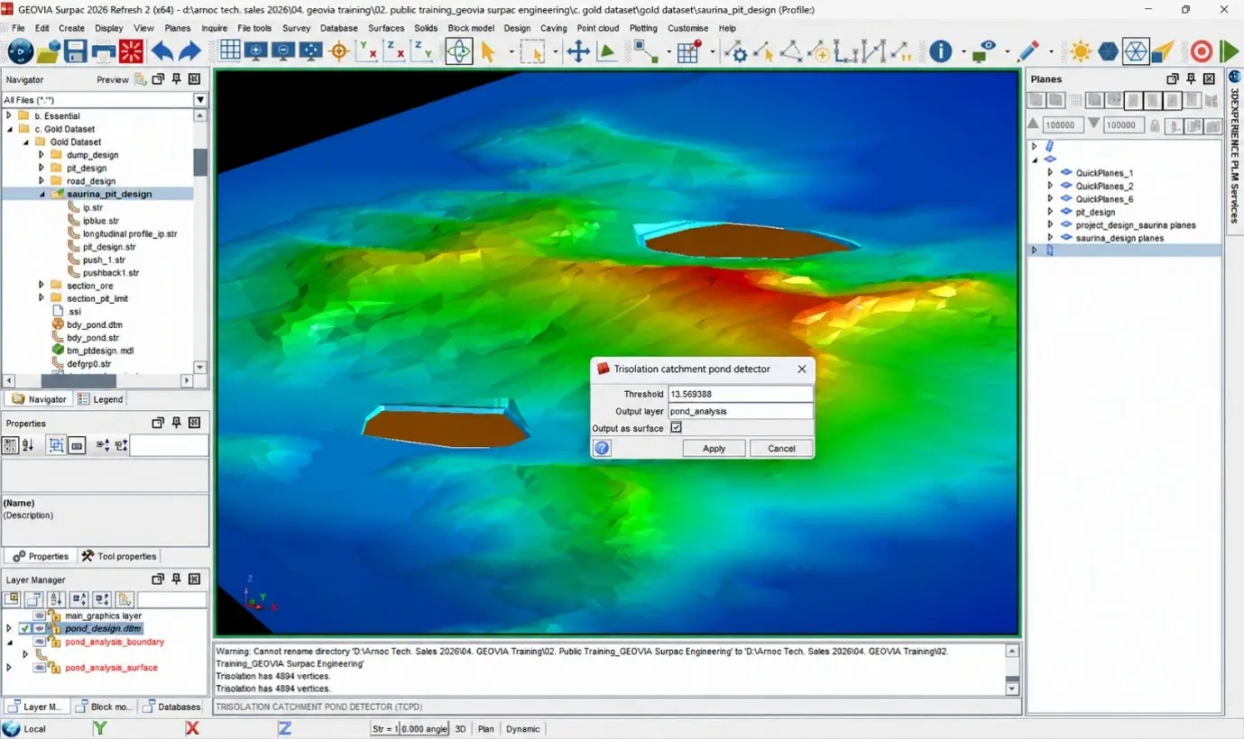
The new TRISOLATION Catchment Pond Detector automatically analyzes a Digital Terrain Model (DTM) to identify enclosed depressions where water is likely to accumulate (Dassault Systèmes, 2026).
Rather than relying solely on contour interpretation, the tool evaluates terrain geometry using configurable engineering parameters, allowing engineers to distinguish between insignificant surface irregularities and depressions that represent genuine water ponding risks.
The analysis is controlled using two primary parameters:
Minimum Pond Depth Threshold, defining the minimum depression depth required to be considered a ponding area.
Mesh Sampling Resolution, determining the level of terrain detail included during the analysis.
These parameters allow users to tailor the analysis according to project-specific terrain characteristics and engineering objectives.
How Topographic Ponding Analysis Works
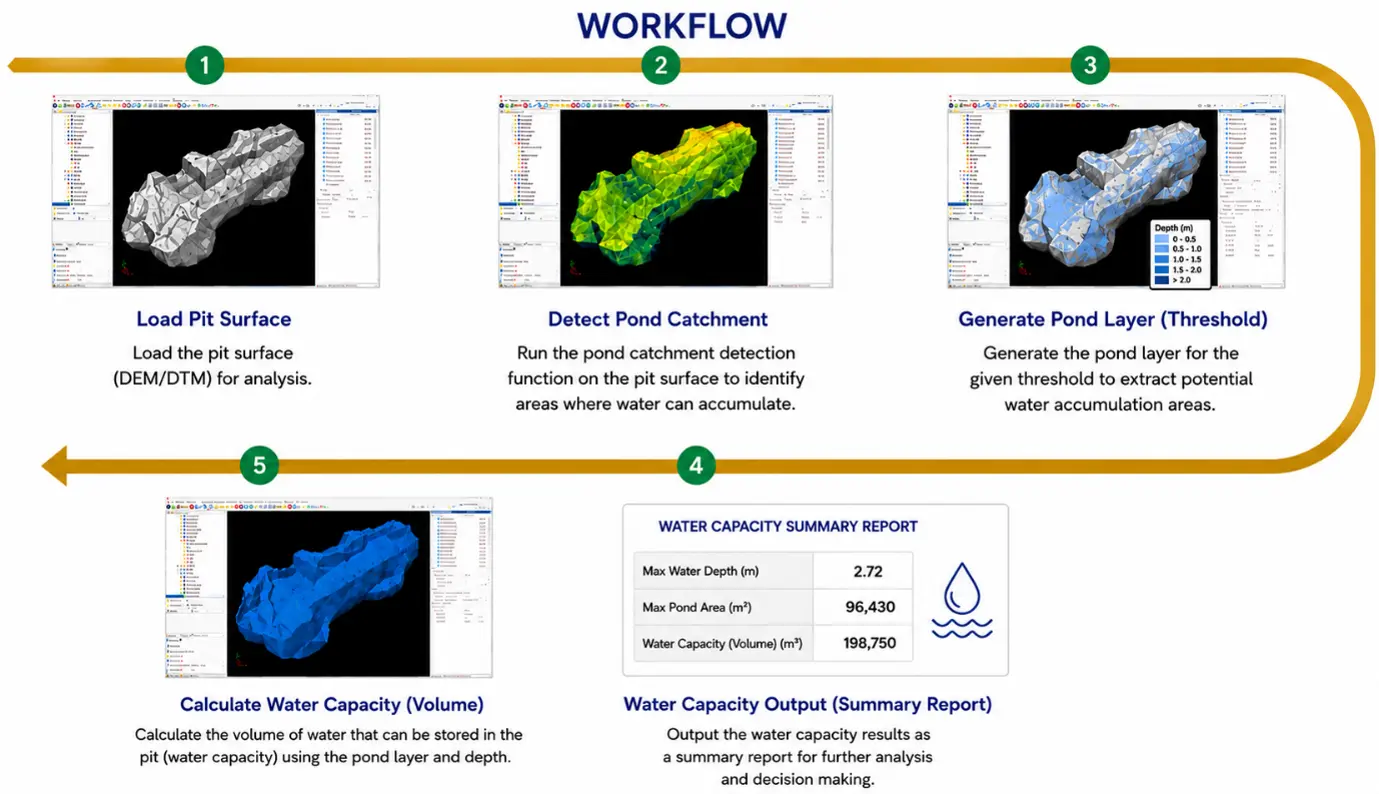
The analysis evaluates elevation differences across the Digital Terrain Model and automatically identifies enclosed depressions where rainfall would naturally accumulate.
Once detected, the tool highlights these ponding areas, allowing engineers to review potential drainage issues before finalizing rehabilitation or mine closure designs (Dassault Systèmes, 2026).
Because the workflow is performed entirely inside GEOVIA Surpac, users can rapidly modify terrain designs, rerun the analysis, and compare alternative landform scenarios without transferring data into external GIS applications.
Engineering Benefits
Integrating pond detection directly into Surpac provides several practical advantages throughout the mine lifecycle.
Faster Rehabilitation Assessment
Automated detection significantly reduces the time required for manual terrain inspection, enabling engineers to evaluate large rehabilitation areas more efficiently (Dassault Systèmes, 2026).Improved Surface Drainage Design
Early identification of potential ponding locations allows additional grading or drainage improvements to be incorporated before construction or rehabilitation progresses.
Better Mine Closure Outcomes
By minimizing unwanted water accumulation, engineers can improve landform stability, reduce erosion risk, and support successful vegetation establishment, which are key objectives of sustainable mine closure (ICMM, 2019).
Integrated Engineering Workflow
Because the analysis operates directly inside GEOVIA Surpac, engineering teams no longer need to export terrain data into third-party GIS software, simplifying data management and improving workflow efficiency.
Practical Applications
Topographic Ponding Analysis can support numerous mining and environmental engineering activities, including:
Mine rehabilitation planning
Final landform validation
Waste dump design
Tailings Storage Facility (TSF) rehabilitation
Surface drainage optimization
Open pit closure planning
Environmental compliance assessments
The functionality is particularly valuable during rehabilitation design reviews, where engineers must demonstrate that reclaimed landforms promote stable drainage patterns while satisfying environmental performance objectives.
Supporting Sustainable Mining
Modern mine closure strategies increasingly emphasize creating landforms that remain physically stable and environmentally sustainable over the long term.
The Leading Practice Sustainable Development Program for Mining Industry highlights that effective rehabilitation design should minimize erosion, support natural drainage, and reduce long-term maintenance requirements (Australian Government, 2016).
By enabling engineers to identify drainage issues early in the design process, Topographic Ponding Analysis supports these objectives while helping organizations improve rehabilitation quality and reduce long-term environmental risk.
Conclusion
The Topographic Ponding Analysis capability introduced in GEOVIA Surpac 2026 Refresh 2 provides mining engineers with an efficient solution for evaluating post-mining landforms and identifying potential water accumulation areas directly from Digital Terrain Models.
Through automated depression detection based on configurable engineering thresholds, the feature simplifies rehabilitation assessments, improves drainage design, and contributes to more sustainable mine closure planning.
For mining organizations seeking to enhance environmental performance while streamlining engineering workflows, this new capability represents another important advancement toward smarter, data-driven mine design.
References
Australian Government, Department of Industry, Innovation and Science. (2016). Mine rehabilitation. Leading Practice Sustainable Development Program for the Mining Industry.
Dassault Systèmes. (2026). GEOVIA Surpac 2026 Refresh 2 – What's New. GEOVIA Product Documentation.
Hancock, G. R., Willgoose, G. R., & Evans, K. G. (2003). Testing of soil and landform designs for post-mining rehabilitation using landscape evolution models. Earth Surface Processes and Landforms, 28(11), 1263–1283. https://doi.org/10.1002/esp.518
International Council on Mining and Metals. (2019). Integrated mine closure: Good practice guide (2nd ed.).