
Introduction
Grades or other geological properties in resource estimation is a spatially correlated variables that being assigned to blocks in the block model. While these blocks represent the volume used in resource reporting, mine planning, and engineering design, the drillhole data that supported it are much smaller in scale relative to the block size. To address this, each block will be discretized into several points. Block discretization is practically important in geostatistical workflows (e.g. Ordinary Kriging) to obtain more accurate and less computational work (Sunday and Deutsch, 2020)
Concept of Block Discretization
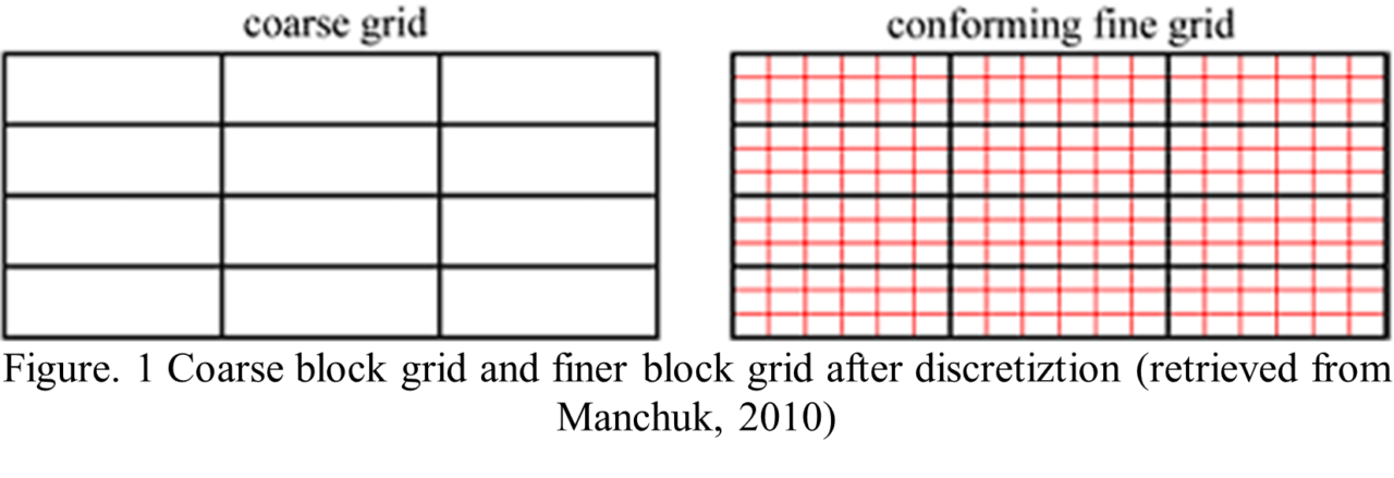
Discretization means subdividing a space into a series of points or a method for transforming coarse grid into a set of conform finer grids (Manchuk, 2010) to address variation of grades or other properties within the block volume. Each discretization point or node represents a volume that is an integral part of the grid block under consideration. When interpolating values using geostatistical methods such as kriging, grid refinement and point-based modeling play a fundamental role in capturing the internal variance of properties within each grid block
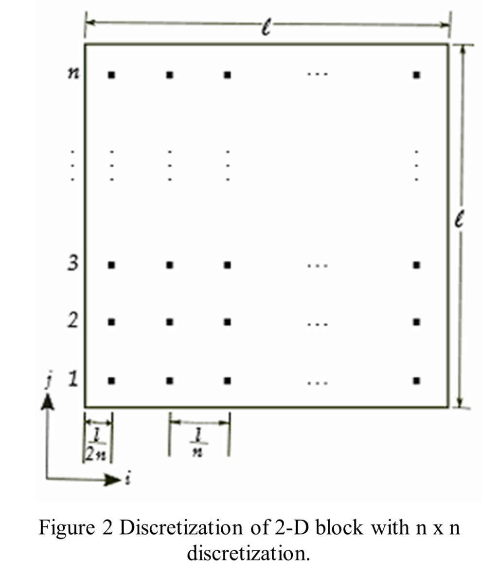
As an illustration, consider a 2-D block of size l, discretized into an n × n regular grid. Instead of treating the block as a single point, it is subdivided by n × n grid of evenly spaced discretization points.(. The value z_ij represents the block property at each discretization point, where i,j=1,…,n define the location within the block (coordinate of XY). Deutsch & Journel, 1997).
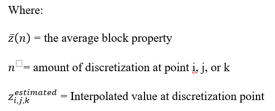
In Surpac, the Geostatistics estimation in one block is done by calculating the average relationship between the sample data and all discretization points inside the block, rather than estimating the grade at only one location. This improves the accuracy of the block grade estimate. If a discretization point has no sample, its value must be estimated or simulated from nearby samples; the block-averaging formula is applied only after all discretization points have values.
In block kriging, the estimation is done by calculating the average relationship between the sample data and all discretization points inside the block, rather than estimating the grade at only one location. This improves the accuracy of the block grade estimate. In geostatistical simulation, the same idea applies. Blocks are represented by a set of simulated points to capture internal variability. Although simulations are performed at the data scale, it is not practical to exhaustively simulate at the scale. Instead, using a reasonable number of discretization points will suffice. The scale of discretization that check the requirement within reasonable calculation depends on several factors:
1. The block dimension
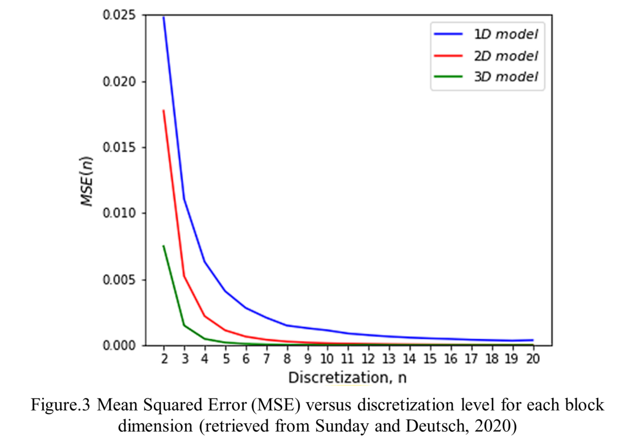
The scalar properties of our block model whether it was 1, 2, and 3-D. Based on Sunday and Deutsch (2020) finding, the high dimensional model the less the error and higher discretization points implies higher resolution and reduced error. In practice, discretization levels of 8 points in 1D, 5×5 in 2D, and 4×4×4 in 3D are commonly adopted, as they achieve low absolute errors while additional discretization offers minimal relative improvement.
2. Spatial Correlation
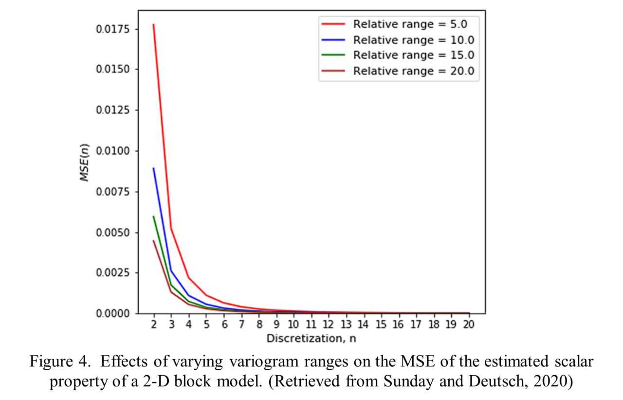
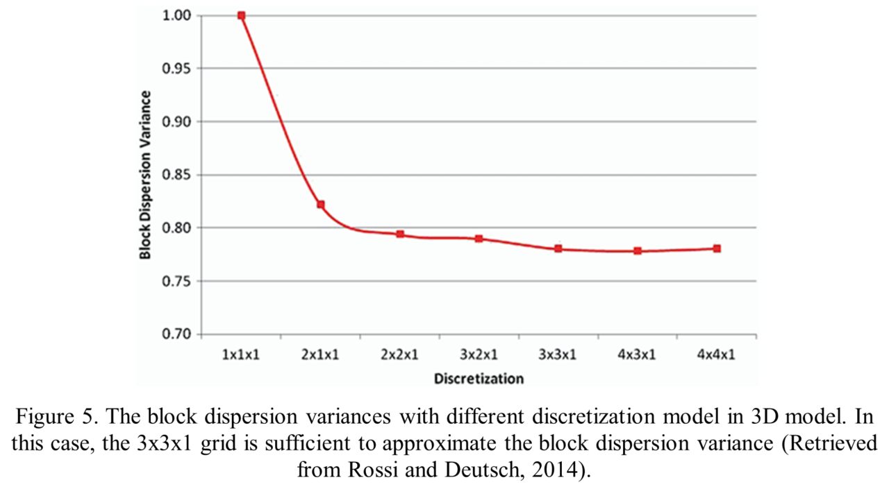
The variogram play an important role in choosing the required discretization level it is implied that the MSE decreases with an increasing variogram range, especially for lock model in lateral direction (X and Y) as it is highly influenced by the supporting data distribution across the XY plane. Based on study on 2-D block model, the 5 x 5 and in 3-D block model the 4 x 4 appears reasonable for all variogram range values and its sufficient to obtain a robust estimate the variance within blocks. Considering too many discretization points could lead to numerical precision problems. One option is to obtain the dispersion variance for several discretization grids
3. Composite Size
The XY discretization value highly impacted by the spatial correlation, meanwhile the Z value of the discretization point in 3-D block model mainly influenced by composite length. In open pits mining, the selectivity in vertical dimension can be based on the geological characteristic of the ore or the general sample length in early-stage analysis and based on the fixed at the bench height for SMU modeling. Meanwhile, in the case of underground mining, selectivity is a function of the mining method (Rossi & Deutsch, 2014). Consider a 20×20×20 m SMU with 10 m vertical drillhole composites, the vertical discretization equals the block height divided by the composite length (n = 2), making a 4×4×2 discretization a reasonable choice
4. Nature of Upscaling
Geostatistical methods (like simulation or kriging) usually describe geological properties (e.g. permeability, grade, porosity) at a very fine scale. However, engineering models (such as flow simulation or mine planning) work at a much larger block scale. Upscaling is the process of converting detailed, small-scale geological information into effective properties that represent a larger block, while still capturing the influence of small-scale heterogeneity. The number of recommended discretization points for flow-based upscaling remains the same as for a scalar property: 5 by 5 for 2-D and 4 by 4 by 4 for 3-D.
Conclusion
Grid block discretization has practical application in resource estimation especially for geostatistical estimation like Kriging. Geological and Resource models that built by reasonable discretization level is expected to yield more accurate estimates. To model a 2-D block, a 5 by 5 discretization is recommended as it provides a stable value with low error. For a 3-D block, a 4 by 4 by 4 discretization is recommended. Although for for 3-D block model, the composite data should take into consideration and adjust to it.
Reference:
Deutsch, C. V., & Journel, A. G. (1997). Geostatistical software library and user’s guide. Oxford University Press, New York, U.S.A.
Manchuk, J. (2010). Geostatistical modeling of unstructured grids for flow simulation (PhD thesis). University of Alberta, Edmonton, Canada.
Rossi, M. E., & Deutsch, C. V. (2014). Mineral resource estimation. Springer Science & Business Media, Dordrecht; Heidelberg; New York; London.
Sunday, C.A & Deutsch, C.V. (2020). Choosing the Discretization Level for Block Property Estimation. Retrieved from GeostatisticsLessons.com